Contents of the summer 2009 Northants News

              Cacti on the Backpacker Trail                          Andrew and Roland Tebbenham        


My son Andrew spent six months backpacking with two friends in South America, Australasia and South-East Asia. He took more than 3000 pictures to record his trip, a few of which showed interesting plants to keep his Dad happy! My 60th birthday e-card from Peru featured a yellow flowered Opuntia – I was touched by such a thoughtful gesture. In this piece we have included some edited extracts from Andrew’s blog and images of various cacti, some nice bromeliads and a mesemb he saw on his journey.

PERU – COLCA CANYON

The Colca Valley is a colourful Andean valley with towns founded in Spanish Colonial times. Colca Canyon was formed by the Colca River some 160 kilometers (100 miles) northwest of Arequipa in southern Peru. It is more than twice as deep as the Grand Canyon in the USA, though the canyon walls are not as vertical as those of the Grand Canyon.


Andrew up close with Cereus.

View of the Colca Canyon, Peru with Opuntia

View of the Colca Canyon

“After a pretty bumpy bus journey our first stop was a small town called Cabanconde situated close to the canyon. We tried Alpaca for the first time, which wasn't too bad, but a little tough. Then it was off to bed as we planned to get up early to trek to the bottom of the canyon where there was an oasis. We got up bright and early and we descended quite quickly, the views were amazing and there was vegetation everywhere including loads of cacti.”

“After the canyon trek we caught the bus to Cruz del Condor to see the Andean condors that obligingly perched on rocks for pictures amongst the silver-leaved bromeliads.”

View of the Colca Canyon, Peru with condor

Andean Condor with Bromeliad at Cruz del Condor, Colca Canyon

PERU – INCA TRAIL

This was a four day journey with guides and a support team to set up camp and cook for the trekking party. Andrew found one ceroid cactus for me amongst the lower-altitude vegetation and some beautiful bromeliads at higher altitudes on the way to Macchu Pichu.

“The first day was easy and there was not much uphill walking to be done. We reached the first campsite ahead of schedule and got our first taste of the really nice food. Apu, the chef, whipped up so many different meals along the way, all with a tiny gas stove and one assistant. It was really amazing how organised they all were. The porters or Chaskis (Inca for messenger) ran ahead of us with huge packs and set everything up before we arrived. The second day was the hardest as we were ascending to 4200m to ‘Dead Woman’s’ Pass, named because the rock formation at the top supposedly resembles a dead woman! The views were amazing and it was nice to know the toughest part was over. We had a short walk down the other side to our camp site where we washed in a stream before playing cards and eating lots of food before getting some much needed rest! The third day featured amazing views and some great Inca sites. It was a relatively flat trek and we saw many orchids and some wildlife along the way. The following day we rose from our beds (albeit unwillingly) at about 4am for breakfast. We trekked up the aptly named 'Gringo Killer' 60 steps, which were almost vertical, to the Sun Gate. It was a really great moment to get our first glimpse of Machu Picchu; it is an amazing place!”

Trichocereus near the Salar de Uyuni, Bolivia

Salar de Uyuni, Bolivia

Salar de Uyuni, Bolivia

Views of Trichocereus tersheckii against the Salar de Uyuni, Bolivia, the world’s largest salt flat .

Trichocereus tersheckii

BOLIVIA – SALAR DE UYUNI

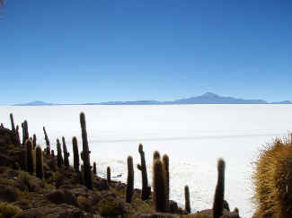
The Salar de Uyuni is located in the Potosí and Oruro departments in southwest Bolivia, near the crest of the Andes at an altitude of 3,650m. It is the world's largest salt flat at 10,582 square km (4,085 square miles) and was formed some 40,000 years ago from a massive prehistoric ocean that dried out leaving smaller lakes and two salt deserts, Salar de Coipasa and the larger Salar de Uyuni. It is estimated to contain 10 billion tons of salt, of which some 25,000 tons is extracted annually. It is also the breeding ground for three species of South American Flamingo and being so flat it serves as a major transport route across the 
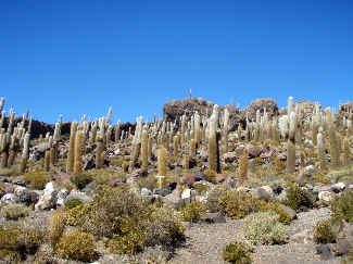
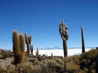
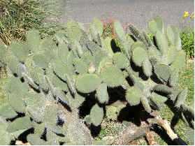
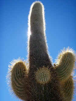
Bolivian Altiplano. Coral islands were formed in the original ocean, one of 
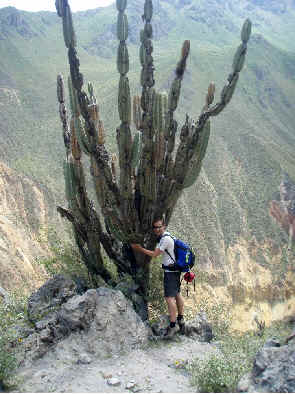
which, Isla del Pescado, is a notable habitat for Trichocereus tersheckii (my thanks to Brian Bates for confirming this by email). The plants are very numerous, with some well-branched older specimens and younger plants indicating regeneration. The setting in a white expanse under a clear blue sky must be unique.

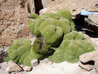
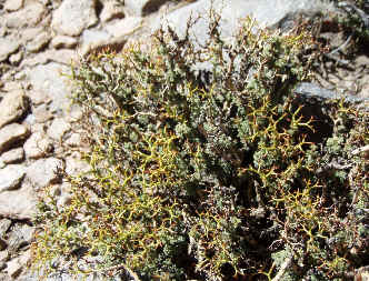
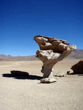
The surrounding landscape includes volcanoes with active vents, geysers, hot springs and brightly coloured lagoons. The combination of cold and wind has eroded rocks into amazing shapes and the saline desert is habitat to unusual plants including the slow-growing Azorella and an unknown halophyte.

SALTA, ARGENTINA

“Salta is a really nice small city with great restaurants and bars. We bumped into an Australian couple from our Inca Trail group who we had also seen at the Uyuni Salt Flats. We ate some fantastic steaks which I cut with my fork they were so tender! After a night of good dining and drinks we rested up before going in a cable car to the top of Cerro San Bernardo a mountain which overlooks Salta.”


Humps of Azorella in the high Bolivian desert

A halophyte in the saline desert

Left: Azorella creeps across rocks in the Bolivian Altiplano Right: An unusual halophytic plant

Andrew spotted a clump of Opuntia (above) that looks a trifle large for my greenhouse. Since cactus hunting was not his primary activity, he and his friends headed for another great steak meal before a 23-hour bus journey to see the Iguazu Falls!

El Arbol de Piedra

Left: This strange rock is known as ‘El Arbol de Piedra’ or ‘The Rock Tree’ – it is 5m tall and was formed through wind erosion by shards of volcanic glass and salt particles.

FRASER ISLAND, AUSTRALIA

Fraser Island stretches over 123 kilometres along the southern coast of Queensland; with an area of 184,000 hectares it is the largest sand island in the world and is a listed World Heritage site.

Mesemb intoduced to Australia

Succulent species introduced into the Australian landscape. Above: Mesemb. Right: Opuntia

 It is particularly beautiful with its long uninterrupted white beaches flanked by strikingly coloured sand cliffs, and more than 100 freshwater lakes, some tea-coloured, others clear and blue, all ringed by white sandy beaches. Ancient rainforests grow in sand along the banks of fast-flowing, crystal-clear creeks. The low ‘wallum’ heaths on the island are of particular evolutionary and ecological significance; they provide magnificent wildflower displays in spring and summer.

“We drove along the beaches to Indian Head and walked up to the cliffs. There were amazing views of the long sandy beaches to both north and south. We saw humpback whales in the distance which jumped and breached out of the sea! We also saw some sting rays and sea eagles.”

Fraser Island with introduced Opuntia

Andrew found time in his busy schedule to record two introduced species: a straggly Opuntia and a mat-forming member of the Mesembryanthemaceae with nice pink flowers. As many of you know the introduction of Opuntias to mainland Australia proved to be a great mistake; it seems they have also colonised this wonderful island off the eastern coast.

Some of the plants Andrew saw are scruffy, massive or totally unsuitable for UK greenhouses, but the images show their natural habitats or places far from their home ranges where they have been introduced by humankind. We hope you enjoy the snapshots of a 58,900 kilometre (36,600 mile) adventure.

Andrew & Roland


back to contents of Northants News